| The ruins of
Fort Union now face unprecedented challenges as increased cycles of
extreme weather from climate change undermine and topple walls, destroying what has stood for over 150 years. |
|
In 2012,
the National Park Service (NPS) Vanishing Treasures program
initiated a multi-region project to address climate change impacts
associated with cultural heritage resources . Information was collected on existing and emerging tools,
policies, baseline data, and context studies to serve as the
foundation for an integrated framework for risk and vulnerability.
Specific tasks
included: |
- Compilation
of existing data (including climate models and predictions)
and literature on climate change and the degradation
of heritage resources by a variety of threats.
|
- Identification
of climate parameters that are most destructive to the built
environment, especially earthen architecture
|
|
NPS
completed the above work in December 2014. The products included the
development of a summary document titled Cultural
Resources Climate Change Strategy that reviewed and evaluated
existing
climate change and cultural resources information/data and identified
priority emphasis areas for future project phases. This initial
research was vital to the overall plan created by the Center for
Architectural Conservation (CAC).
|
|
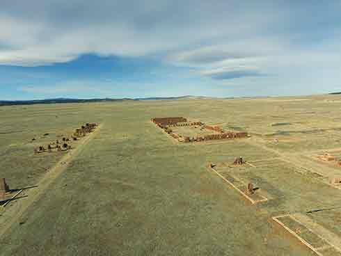 |
ABOVE: A view from the height of the fort's
original flagpole looking north up the Santa Fe Trail. From this
perspective the Mechanics Corral and Depot buildings can be seen in the
center.
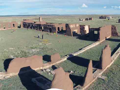
RIGHT: Looking southeast as team members survey the interior walls
of the Mechanics Corral. |
|
| Starting in
2015, the Center for Architectural Conservation (CAC), in
conjunction with students in the Graduate Program in Historic
Preservation at the University of Pennsylvania carried out research at
Fort Union in an
attempt to identify visible changes in the adobe walls of one portion
of the fort, the Mechanics Corral. The goal of this research was to identify
possible
causes for those changes based on comparison with previous NPS data, including a 1995 NPS survey that attempted
to identify wall conditions, as well as Superintendent's Reports
written since the park was first established. From this early research,
the work which followed included creating a terraced approach to
assessment and treatment that would allow the park to independently
prioritize areas in need of treatment for the entire site through the
use of a comprehensive rapid assessment survey. |
|
|
 |
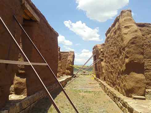 |
| The walls of the hospital building range in
height from non-existent to over 20 feet. In several locations they have
been braced to keep them from collapsing. |
|
The
majority of the existing adobe walls of the
third Fort Union define the Hospital, the Post Officer’s Quarters, the
Depot Officer’s Quarters, and the Mechanics Corral. A rough estimate of
surviving adobe walls in these sections combined, suggests
approximately 5000 linear feet of adobe wall or approximately the
equivalent of one mile. While all of the adobe walls vary in height,
they average five feet in height, or a total of approximately 50,000
square feet of
surface area, equivalent to over an acre of surface. As
weathering continues to impact the standing ruins, and the fear for
catastrophic failure increases from intense weather episodes,
preventive anticipatory conservation will be far
more important than
remedial
interventions for the
long-term management of the site.
In order
to identify site susceptibility to weathering, the CAC is coordinating
methods for the survey, analysis, and
interpretation of risk and vulnerability for the ruins. The coordinated methods include the following:
- A field survey of the existing
walls of the Mechanics Corral.
- Environmental monitoring of wall
and site conditions.
- Preparation
of architectural base drawings
identifying critical aspects such as wall height, integrity, openings,
wall juncture details, image comparisons, plaster location, bracing
type and location, and wall deformation.
|
|
|
|
|
|
|