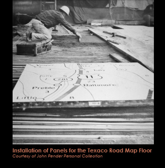
One of the most popular attractions at the Pavilion’s Tent of Tomorrow was its enormous terrazzo pavement based on a Texaco road map of the state of New York. Designed by Philip Johnson Associates following ancient precedents in depicting the world as a pavement, the Pavilion’s floor celebrated a familiar icon of American pop culture-the road map. Conceived to be the largest geographic representation in the world, the pavement was also the most extensive terrazzo project ever undertaken at the time, costing approximately $1 million to complete. Rand, McNally & Company supplied the topographic information, while Texaco provided the location of each of its state gas stations. The enormous map is composed of 576 individual panels, each measuring 4’x4’, which span a total of 130’ by 166’. Each panel weighs approximately 400 pounds, creating an entire pavement weighing in at a staggering 114 tons.
To create the colossal map, each of the three-quarter inch grid sections from a Texaco map were magnified 64 times and projected onto 4’ by 4’ paper templates. A group of Yale University art students then meticulously traced the enlarged roadway network, topographic symbols, letters, numbers and Texaco station logos by hand. The templates were sent to Manhattan Tile and Terrazzo Co. (now Manhattan American Strip Co.) to duplicate the topographical markers in metal strips and colored plastic insets. These components were all hand cut and then carefully arranged in plywood pattern boxes. The boxes were sent to the Port Morris Tile and Marble shop, where the terrazzo mixture of Portland cement, marble chips and crushed glass was poured. Various pigments were added exactly reproducing paper map features such as land (white, green, and tan), roads (black and red), and rivers and lakes (blue). Finally, the pavement surface was ground smooth and polished.
The finished cast tiles were then transported to the Pavilion site, and laid individually on a bed of sand reinforced with galvanized steel mesh, using suction-cup lifts to move each panel in place. The panels are all supported beneath by a structural concrete slab. Additionally each panel’s outer frame contains pins on each side to interlock with its neighboring panel. The entire map is designed in this way forming a staggered “mosaic” of panels that are interlocked with each other.
The map pavement was an instant success. Fairgoers interacted with the giant map locating themselves in the present (“You are here”) as well as in the past as personal histories through the geographic space provided. Texaco operated a “Travel Information Booth” while young fairgoers rode across the state in miniature cars. Like the Tent itself, the Texaco map pavement was another example of Johnson’s brilliant incorporation of American pop material cultural in promoting the Fair’s theme of “man in a shrinking universe.”
The Madaba Map
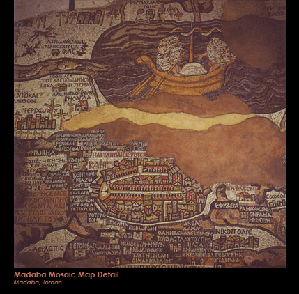
Historically very few maps executed as pavements survive. However, one of the most important examples can be found in a Byzantine church in Madaba, Jordan. First discovered in 1898,and dated to approximately 542 to 565 A.D., the Madaba Map is considered one of the oldest Christian maps and depicts the Holy Land, stretching from the Mediterranean Sea to the Arabian Desert and from the city of Tyre to the Nile River. The central focus and most famous segment of the map details the walled city of Jerusalem. Individual historic place names were recorded in Greek lettering, of which about 150 are intact today. Scholars believe the original map would have measured approximately 80 by 20 feet and would have been a considerable undertaking, requiring craftsmen to lie over two million individual mosaic tiles. Sadly, today only approximately one-third of the original map survives.