 |
ACL Project List |
 |
|
||||||||||||||||||||

Encircling the excavation from atop the escarpments, the visitor circuit spans nearly 880 meters over relatively level terrain and provides viewing access into the Citadel Mound and outward to the surrounding landscape. The current lack of basic amenities and poor condition of the circuit’s paths, steps and perimeter railings contribute to an inadequate visitor experience. As a major component of the Conservation Program, the visitor circuit requires extensive upgrades to improve visitor navigation and interpretation.
Originally designed to afford visitors views of Gordion’s excavated features, including the Early Phrygian Gate, Terrace Building Complex and Megaron buildings, the visitor circuit provides only rudimentary access to the archaeology and surrounding landscape. Irregular stone steps have been placed in several sloped locations—most notably to the north and south of the gate—to provide access to the top of the Citadel Mound. Barbed wire fencing had been installed along the entire circuit perimeter to operate as a safety barrier between the visitor and excavation. Currently, interpretive signage exists at four primary locations along the path and provides only basic information on Phrygian culture and the Citadel features.
|
 |
 |
 |
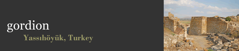
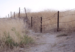
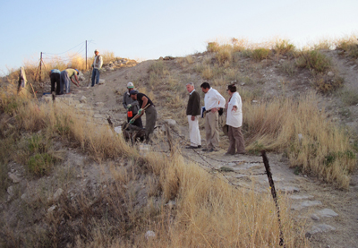
The pilot program implemented during the 2009 season addressed the degraded condition of the visitor circuit path, steps and perimeter railings (right, 2006), and included the installation of wayside viewing platforms. The process (center, during step replacement) was focused on upgrading materials at the segment north of the Early Phrygian Gate (right, completed segment in 2009).
|
Condition of the Visitor Circuit Factors contributing to the inadequate visitor experience range from the poor condition of existing features to the lack of basic amenities. With little to no maintenance, the footpath suffers from unstable steps and the overgrowth of native grasses. Although vegetation does not inhibit circuit use, the grasses obscure the path, and deteriorated stone steps present safety issues at several steeply sloped areas. The heavily rusted barbed wire perimeter fencing stands as an unattractive and oppressive feature along the circuit and is an inappropriate selection for an archaeological site open to tourists. The site’s few interpretive signs have succumbed to the harsh environmental conditions and exhibit varying degrees of deterioration at their concrete footings, posts or plaques. Victim to vandalism, the plaques have also been bent and scratched, although the text remains legible. Finally and most importantly, several areas of the visitor circuit traverse undercut escarpments and pose a serious hazard for visitors and danger to the features below.
Aside from physical conditions resulting from the environment and vandalism, the site suffers from too few visitor amenities. With no bathrooms, benches, shaded rest areas or wayside viewing platforms, the average visitor passes through the site with few stops and little understanding of the extant architectural features, innumerable archaeological objects uncovered during the sixty year excavation history or the many periods of occupation at the Citadel. |
Program Implementation First implemented during the 2009 field season, conservation efforts identified through the Conservation Program were focused on upgrading public access and experience by designing and installing a circuit prototype, which included new perimeter railings, stone steps, signage and wayside viewing platforms. The materials and design selected for the visitor circuit prototype refined the aesthetic and increased site appeal to create a more welcoming experience for visitors. Improvements to interpretation and understanding of the architectural and archaeological features were vital characteristics for the installation of the new segment of the visitor circuit. The upgrades were also implemented with the objective of lengthening the average visit and establishing a connection between the Citadel Mound and its surrounding context—including the Central Anatolian landscape, neighboring tumuli, the village of Yassıhöyük and the Sakarya River landscape.
|
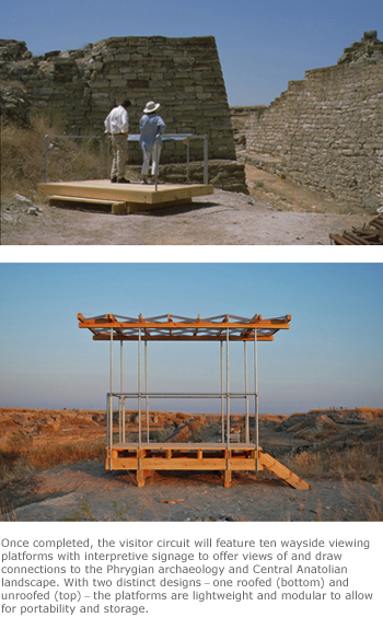 |
| Plan, section and elevation drawings of the roofed visitor circuit wayside viewing platform prototype by project architect Lindsay Falck, 2009. |