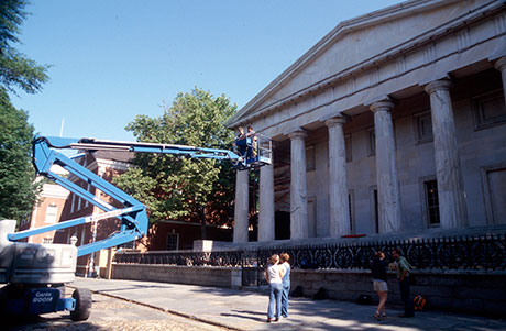
 | | A highlift being used on the south facade. |
|
|
|
Phase 1
of the assessment survey began with the north and west elevations. The
exterior masonry conditions survey was completed during Phase 2 of the
project, surveying the south and east elevations in 2003. Since the
work carried out on the Second Bank of the United States actually
spanned two different phases, efforts were made to maintain consistency
from one phase to the other; however differences did occur which helped
the ACL to test the repeatability of the building conditions surveys.
Presently, all of the exterior masonry of the building has been
carefully inspected, the conditions recorded, digitized drawings
produced, the final product field checked and preliminary assessments
formulated. Data gathered from the exterior masonry survey has been
used in preparation for GIS-based diagnostic assessment and remedial
and preventive intervention.
|
|
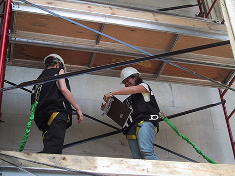 |
| Teams followed proper safety procedures when working on high lifts and scaffolding. |
|
|
Phase 1 was conducted from June 7 through July 16,
1999. A total of six graduate and post graduate interns conducted a
complete investigation of both elevations with the use of movable
scaffolding and 60’ and 45’ high lift cranes with extending booms.
Teams
alternated between recording conditions in the field and digitizing
those conditions in AutoCAD over the new drawings. During the six-week
field school, all elevations of the portico including the columns,
pediment, ceiling, flooring, and stairs as well as the entire west
elevation were surveyed and digitized. Two interns continued for a
three-week period beyond the field school to check and complete the
survey drawings. |
|
 |
|
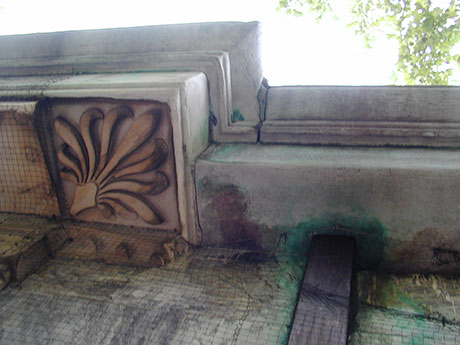
| In many locations on the building,the stone has suffered from a wide
range of conditions including soiling, erosion, spalling and staining. |
|
|
|
| In 1999 a
multi-phased conservation plan was developed and initiated with
Independence National Historical Park beginning with the preparation of
a detailed CAD based survey of the exterior masonry conditions based on
early HABS recording and the compilation of a history of past repairs
and treatments to the building. |
|
| | Phase 2 of the survey was conducted from June 2
through July 11, 2003 by a total of five graduate and post graduate
interns. Movable scaffolding and a 60’ high
lift crane were used for
recording and documentation purposes. AutoCAD line drawings from the
1999 survey were modified and adapted to the south and east elevations
to be used as base drawings for conditions recording. The drums of the
columns were accurately measured while all other joint lines on the
ashlar walls, steps, and floor were carefully approximated by eye. For
surveying purposes, the team divided the conditions into five groups
and assigned each group to one team member. This decision was made in
order to ensure consistency across the survey in an effort to combat
against the sometimes subjective nature of conditions recording despite
detailed glossaries. All conditions recording of the entire east
elevation and south portico including the columns, pediment, ceiling,
mutules, entablature, floor, and stairs was completed during the
six-week field school. Three interns continued for two to three weeks
beyond the field school to begin the digitization process. One intern
continued over the course of the fall and winter to complete
digitization and lay out the final set of drawings.
Documentation in
the form of digital photography was also made during time spent in the
field. When an exemplar condition was found, it was photographed for
use in the revised glossary. Unique conditions and complex
deterioration patterns were also photographed, along with construction
details that could only be seen with the aid of the high lift or
scaffolding. Digitization was a three-step process using Photoshop,
AutoCAD, and ArcView software. |
| 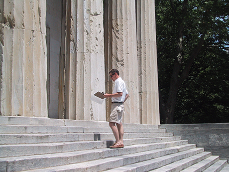 | | The
columns showed the most deterioration and the final assessment created
an opportunity for a second project with the Park carried out in 2011
using Surface Penetrating Radar. |
| | As a result of two different teams recording conditions, the final full survey had discrepancies. On the Second Bank, the north and south facades are
almost identical, as are those of the east and west. By having the south and
east facades surveyed in 2003, and the north and west facade surveyed
in 1999, a comparison showed that the results of each phase differed
when comparing areas of the same condition, suggesting that the system
in place was not adequate to ensure consistency. Conditions,
while well defined, can be subjective and are ultimately defined by the
individual who is recording them. This is especially true when
addressing the fine nuances that differentiate one condition from
another. As a result of this variation, the ACL adopted new
guidelines for all their future surveys.
During
Phase 1, individuals were asked to record the entire set of conditions
within a given portion of the overall survey area. Since differences
were noted from one area to the other, during Phase 2, all the
conditions were divided into sets. Each person was assigned a set and
was asked to record those conditions for the entire survey area. The
work load was consistent with that of the 99 survey however the results
were not, showing much more consistency across the entire surface.
After
a thorough introduction of all conditions to the entire team, each
person was asked to write comprehensive definitions for their assigned
conditions and compares them with the other definitions in the group.
this process helped individuals better define their own conditions.
Finally
each individual was required to capture at least 3 photographs of each
of their conditions which could be used in the final printed
glossary. These photographs needed to clearly show the defined
condition and show its full range. |
|