To date, there has been little
coordinated attention to describe how
changing weather conditions will affect built heritage at the material
and systemic level. Only with a better understanding of damage
mechanisms can we begin to implement remedial and
preventive strategies, including the establishment of monitoring
programs that can measure projected impacts to these resources.
Urgent levels of mitigation and support adaptation are required to reduce
vulnerability from current and future climate extremes.
Where adaptation is not undertaken in response to a perceived risk,
vulnerability will remain unchallenged.
|
|
|
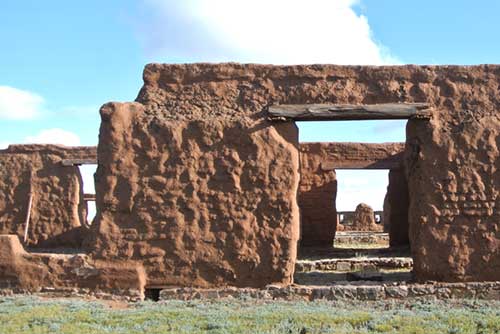
In raking light the texture of the original adobe block walls can be seen beneath the protective shelter coats.
|
|
|
|
| Monitoring,
or the systematic process of observing, tracking, and recording data
for the purpose of measuring and assessing information deemed necessary
for a stated objective is the key to cultural resource management.
There are many monitoring systems now in place that capture how climate
is changing. They do not, however, provide information about the
impacts of changing climate on built cultural resources at the park or
site level. |
|
|
|
| The challenge for cultural
resource managers is to develop a suite of indicators at multiple scales that are essential for
understanding climate impacts on built heritage (e.g.,
materials, construction systems, conditions, settings). These
indicators should capture sufficient information to demonstrate change
relative to climate stressors and, therefore, provide some insight into
future weather-induced damage. Because it is not realistic to measure every phenomenon on a site, it is
important to identify aspects,
including condition, that provide a generally accurate basis for
anticipating future problems. These indicators should be directly linked
to the problem, measurable, and
ideally display a time continuum (exist in the past and present).
Such information could be useful for any site, focusing on measurable
metrics that can be used as indicators of site vulnerability
and site sustainability. |
|
|
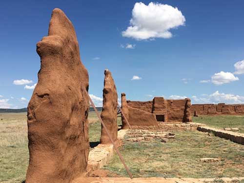
Walls, impacted by prevailing winds, supported by additional bracing to prevent catastrophic failure.
|
|
| As with natural ecosystems, cultural resources
have the capacity to adapt to a changing environment but this adaptation is limited by time and space as
well as the intensity of the change. For example, annual summer
‘monsoons’ will continue to erode the adobe walls of
Fort Union; however, changes in the occurrence of
these monsoons, due to climate change, will
stress the walls beyond their moisture threshold limits resulting in
catastrophic failure due to adobe’s wet strength
vulnerability. The aim is to provide a framework for
defining site vulnerability and threshold limits based on site
monitoring that integrates across a wide range of scales and over time. |
|
|
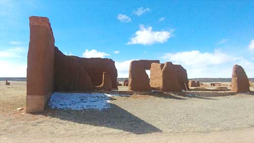
A view of the southeast end of the Mechanics Corral showing where snow can remain in shadowed areas.
|
|
| The Integrated Vulnerability Assessment Methodology developed by the CAC team is
intended to differentiate modes of deterioration based on their
symptoms as well as their degree and frequency of treatability. Certain
treatments, such as the application of shelter coats, are preventive,
low impact, and cyclical. This treatment does not address other
conditions such as deformation or leaning, which require more invasive
interventions. A sustainable conservation and management plan for
climate-sensitive cultural resources, such as those constructed of
earthen materials and maintained as ruins, clearly identifies the type
and rate of deterioration, where it occurs, and what interventions are
necessary to reduce and/or remove the causes of damage. |
|
 |
|
The
Integrated Vulnerability Assessment Methodology is the culmination of
four phases of work conducted by the Center for Architectural
Conservation. This methodology, developed and implemented at the Third
Fort at FOUN, is comprised of three components:
- The Rapid Assessment Survey (RAS)
- Wall Profilometry for validating RAS findings
- Passive RFID embedded monitoring
These three parallel data sets provide the foundation for an integrated
approach that leverages the benefits of both qualitative and
quantitative techniques. Each dataset complements and reinforces the
other, compensating for weaknesses that would otherwise arise from the
implementation of any method in isolation - as is often the failure
with most contemporary vulnerability assessment protocols that
emphasize either quantitative or qualitative tactics.
|
|
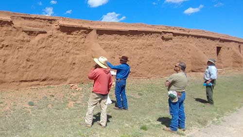
National Park Service stabilization crew executing the new rapid assessment survey during the summer of 2019.
|
|
The
Rapid Assessment Survey (RAS) is the framework of a seasonal
site-wide assessment, intended to substantiate annual
maintenance, stabilization, and monitoring decisions. The primary
objective prioritizes wall sectors based on observed wall conditions
that define vulnerability factors. It does not, however, replace expert
judgment to actualize its findings.
The value of the RAS is derived from consistent
annual implementation, providing a structured observational
approach. It replaces past informal annual surveys, from the early park
forms to the annual site ‘walk-around’ by the stabilization
crew.
|
|

|
CAC staff working on profiles for the Machanics Corral.
|
|
Wall
profilometry characterizes both a wall’s geometrics, as well as its
differential surface deterioration and loss. In addition to its height,
the most valued piece of information for assessing vulnerability of a
freestanding wall is a record of its cross-section. Profile information
is critical to maintenance and preservation, while the resulting
surface deterioration typologies can be beneficial to understand
surface erosion of adobe ruins across the region.
|
|
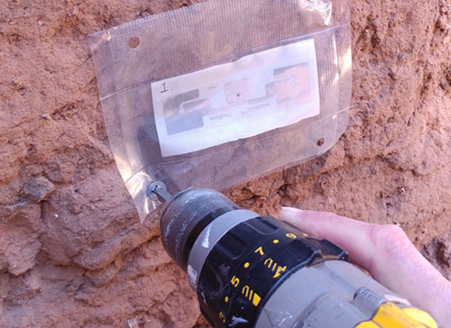 |
Installation of the RFID tags behind the shelter coat of the walls of the Hospital building.
|
|
| Radio identification (RFID) technology, a passive embedded
moisture detection tool, leverages the understanding of the primary
failure mode. As a result, only the data necessary to
evaluate the integrity of the water shedding elements of the
adobe wall are collected, and only when necessary by the preservation staff during the seasonal survey. |
|
The
primary objective of the RAS is risk-prioritization based on inherent
vulnerabilities and the results should be evaluated both intrinsically
and extrinsically. Data gathered from the RAS of the Third Fort,
particularly contextual ‘aspect’ factors such as orientation, exposure,
and wall geometry, provide validating performance scenarios that
suggest certain combinations of both intrinsic and extrinsic factors
have an exacerbating effect on both active and inactive deterioration
conditions and therefore overall performance. This is the essence of
understanding risk and threat and their effect on site vulnerability.
The Integrated Vulnerability Assessment Methodology can lay the
foundation for NPS to develop a long-lived Site Preservation and
Management Plan that can respond to the coming needs of climate change
and diminishing fiscal reserves.
|
|